Bahia
Bahia (pronounced [baˈi.a]) is one of the 26 states of Brazil, and is located in the northeastern part of the country on the Atlantic coast. It is the fourth most populous Brazilian state after São Paulo, Minas Gerais and Rio de Janeiro, and the fifth-largest in size. It is also one of the most important states in terms of history and culture, in Brazil's, and it's only comparable to Pernambuco in Brazilian's Northeast Region. Bahia's capital is the city of Salvador, or more properly, São Salvador da Bahia de Todos os Santos, that is located at the junction of the Atlantic Ocean and the Bay of All Saints. The name is an archaic spelling of the Portuguese word meaning bay and comes from All Saints' Bay, first seen by European sailors in 1501.
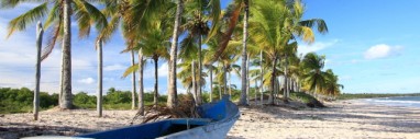
We had a close look at 1000 kilometers of bahian coast gathering info for you. Here you will find the ideal climate for your escape-holiday between october and march, endless sandy beaches, afro-american culture, historical sites in the oldest brazilian towns, especially barock churches, the colourfull carneval, which is celebrated in the streets and at the beaches. This is the place to enjoy your holiday on lonely or lively beaches, in villages, towns and on the road. There are Hotels and Pousadas for every taste and budget. The brasileiros are friendly people who love theyre beaches and love to party. You can be sure that you will be welcome to join in. Visit Bahia and Salvador, the historical capital of Brazil.
History
Historic Centre of Salvador. São Marcelo Fort, in the capital of the state. The Portuguese Pedro Álvares Cabral landed at what is now Porto Seguro, on the southern coast of Bahia in 1500, and claimed the territory for Portugal. In 1549, Portugal established the city of Salvador, on a hill facing the Bay of All Saints. The city and surrounding captaincy served as the administrative and religious capital of Portugal's colonies in the Americas until 1763. The Dutch held control of Bahia from May 1624 through April 1625. Charles Darwin visited Bahia in 1832 on his famous Voyage of The Beagle. The state was also the last area of Brazil to join the independent confederation. Some members in the elite remained loyal to the Portuguese crown after the rest of the country was granted independence. After several battles, mostly in Pirajá, the province was finally able to expel the Portuguese on July 2, 1823, known as Bahia Independence Day, a great popular celebration. In the state there is an ongoing discussion about the exact moment of Brazilian independence, because for almost all baianos, it really happened in Bahia with the battles, and not on September 7, when the Emperor, Pedro I, declared independence. Bahia was a center of sugar cultivation from the 16th to the 18th centuries, and contains a number of historic towns, such as Cachoeira, dating from this era. Integral to the sugar economy was the importation of a vast number of African slaves; more than 37% of all slaves taken from Africa were sent to Brazil, mostly to be processed in Bahia before being sent to work in plantations elsewhere in the country. The oldest Roman Catholic cathedral and the first medical college in the country are located in Bahia's capital, which also has one of the highest percentage of churches of any state capital in Brazil. The Catholic Archbishop of São Salvador da Bahia, Geraldo Majella Agnelo, is the Cardinal Primate of Brazil.
Geography
Fumaça Waterfall. The state's geographical regions comprise the Atlantic Forest. The Recôncavo region radiating from the Bay (the largest in Brazil), the site of sugar and tobacco cultivation. And the Planalto, which includes the fabled sertão region of Bahia's far interior. Bahia is bordered, in counterclockwise fashion, by Sergipe, Alagoas, Pernambuco and Piauí to the north, Goiás and Tocantins to the west, and Minas Gerais and Espírito Santo to the south. The State of Bahia is crossed from north to south by a mountain chain which is marked, in the map, as Chapada Diamantina. This same chain receives other names, like Serra do Espinhaço, in Minas Gerais, and Borborema, in Pernambuco and Paraíba.
Climate
In addition to its considerable size, it has the longest coastline of the country: 1.103 km long (685 miles; north coast: 143; Todos os Santos Bay: 124; and southern: 418). With 68% of its territory located in the semi-arid zone, the State presents diversified climates and an average rainfall that varies from 363 mm to 2,000 mm/year, depending on the region. Regarding the weather, Bahia is one of the most privileged states of the country with the following temperatures: 19.2 to 26.6°C (66.6 to 79.9°F) annual average; 6.1°C (42.5°F) absolute minimum at the municipality of Caetité. And 41°C (105°F) maximum at the municipality of Remanso.
Economy
Vitória da Conquista, the third most populous city of the state. The industrial sector is the largest component of GDP at 48.5%, followed by the service sector at 40.8%. Agriculture represents 10.7% of GDP (2004). Bahia exports: chemicals 22.4%, fuel 17.5%, mineral metallics 13%, paper 9.4%, cacao 5.6%, vehicles 4.8%, soybean 4.5% (2002). Share of the Brazilian economy: 4.9% (2004).[6] The state has the biggest GDP of the states of the North/Northeast of Brazil. Bahia is the main producer and exporter of cacao in Brazil. In addition to important agricultural and industrial sectors, the state also has considerable mineral and petroleum deposits. In recent years, soy cultivation has increased substantially in the state. Bahia is the sixth largest economy of the country. In the mid 1950s, the Bahian economy could be considered a typical example of the primary-exporting model, which followed the subsistence production. For ten years this dynamic was led by cocoa crop that used to be the state's main product and its most important source of income. With the acceleration of the industrialization process in the 70s', which started in the 50s, the productive structure began to change. This process, which was not limited to the regional market, was inserted in the Brazilian industry matrix through the chemical (specially petrochemical) and metallurgical segment. Consequently, for the last twenty years, the dynamism of the Bahian economy has surpassed the national economy and the State was able to present higher growth rates than the ones presented by the national economy. The industrial sector is expected to be the main contributor to this growth, particularly from 1999 on, when the investments that are being made now in the chemical, petrochemical and automotive segment, in agroindustry and food production will be consolidated. Itaparica Island. The Bahian economy began 2005 in a very healthy state, with an exceptional trajectory of growth, once again presenting activity indicators superior to those of the Brazilian economy. Those numbers are the result of the endeavours of the Bahian Government, the result of increasing productive investment, and therefore, potential production, something that has been carried out through attractive enterprise policies in all segments of the economy, placing Bahia in a privileged position in the regional and national scenario. Today, the State has a differentiated economic profile, not just depending on one or two sectors. Bahian industry diversified and widened its productive base, with the implantation of new industrial segments, like the automobile and tyre industries, footwear and textile, furniture, food and beverages, cosmetics and perfumes, Information technology and naval. Exceptional results can be seen in agriculture, commerce and tourism, where Bahia appears as one of the principle national destinies. For this to happen, the strategic position model of Bahia in the international tourism route was fundamental, with direct and regular flights to Europe, the United States, and the Southern Cone, due to the complementary governmental and private initiatives, besides the development of new tourist poles integrated to the local culture.
Tourism and recreation
Beach in Itacaré.
Bahia is the principal tourist center of the Northeast and 2nd of the country. The tourist product in Bahia, 50% of its global flow centered in Salvador, unites in a same space the characteristics of a natural landscape and an unique culture in the country, in which the typical culinary arts, the colonial architecture and popular feasts reveal a strong integration of elements of European and African origin in the formation and in the way of life of the people of Bahia. By its natural and historic-cultural attractions, Bahia presents an enormous potential for the development of the tourist activity. Owner of the biggest portion of seacoast of the country and of singular views in its interior, Bahia possesses specific cultural, folklore and religious characteristics, manifest in its extensive calendar of popular festivities, in its architectonic patrimony and in its typical food.
Salvador, with its Historical Center registered by UNESCO as Patrimony of Humanity and with its coast clipped into many beaches and dozens of islands, has a varied receptive infrastructure, composed of 170 hostelry units (of which 20 are of international standard hotels) and 25 thousand beds, further to restaurants, bars, nightclubs, malls, theaters, crafts centers, Convention and Fairs Center, rental agencies, tourist agencies, and other equipment and services. In the last few years, the State Government promoted the total restoration of the Pelourinho, the biggest set of colonial style buildings in Latin America, today transformed into an important point for visitation by tourists, that will find there a synthesis of what best Bahia has to offer in specialized services, in regional and international cooking, in architecture of the XVII and XVIII centuries and in music, with daily shows by the great artists of Bahia, famous in the country and abroad. The period of popular festivities in Bahia has its high point between December and March (summer months) and has in carnival its supreme point, with more than one million tourists in Salvador, Porto Seguro and other cities of the State's Tourist circuit.
Regoins of Bahia
The Coconut Coast
The Coconut Coast, in the northern of Bahia, corresponds to a total of 193 km (119 mi) of coast line, where coconut groves, dunes, rivers, swamps and sweet water lagoons are a constant scenario as well as the presence of the Atlantic Rain Forest. The Green Road, a road that connects Mangue Seco in the far north to Praia do Forte, crosses this beautiful region maintaining a critical distance from the areas of environmental preservation. For this reason the route is sometimes more than 10 km (6 mi) from the beach. At Praia do Forte, the road meets the Coconut Road (Estrada do Côco) and leads to Salvador, passing through spots, which are now integrated in the urban development of the state capital. In this region is located the Deputado Luís Eduardo Magalhães International Airport.
All Saints Bay
View of Salvador. The largest bay on the Brazilian coast, Todos os Santos has a large number of islands with tropical beaches and vegetation. In its 1,052 square km, it contains 56 islands, receive sweet water from numerous rivers and creeks, especially the Paraguaçú and Subaé and bathes the first capital of Brazil and the largest in the Northeast, Salvador, and more than ten municipalities. It is the largest navigable bay in Brazil and one of the most favorite spots for nautical sports, due to its regular breezes, medium annual temperature of 26°C (77°F) and sheltered waters. Todos os Santos Bay offers various leisure options, with hundreds of vessels of all different types, especially saveiros, schooners, motor boats, jet ski that criss-cross its crystalline waters on maritime excursions to the islands, and boat races. Major popular events and sport activities occur throughout the year, beginning on January 1, with the Procession of Bom Jesus dos Navegantes greeting the New Year. Todos os Santos Bay has also been traditionally the venue for rowing contests at the Enseada dos Tainheiros, in Salvador, and now the bay is included in the routes of the great international regattas, such as the Ralley Les Iles du Soleil, regatta Hong Kong Challenge and the Expo 98 Round the World Ralley, which consider the bay an important stop along the route. The islands of the bay are a separate attraction. Some are privately owned, others were declared a state heritage and transformed into Environmental Protection Areas or ecological stations. Other islands are the patrimony of 12 municipalities located around the bay. Only a few are uninhabited and many have small communities where the natives live on fishing and tourism. All have common characteristics, such a calm sea, dense vegetation, especially coconuts and bananas, as well as vestiges of the Atlantic Forest. Of the 56 islands, the most important are Itaparica, Madre de Deus, Maré, Frades, Medo, Bom Jesus dos Passos.
Dendê Coast
Morro de São Paulo. The Dendê Coast, south of Salvador, is surrounded by verdant vegetation, clear waters, islands, bays, coral reefs and a very diversified fauna. It is connected to Salvador and the southern part of the state by ferryboats and the BA-001 highway, the second ecological highway along the Bahian coast, which connects the southern coastline and the extreme southern part of the state. It includes the municipalities of Valença, Cairu and the International attractions of Morro de São Paulo, Camamu, Taperoá, Ituberá and Maraú. The mouth of the Rio Una, in the form of a delta, contains 26 islands, the largest of which is Tinharé, where the Morro de São Paulo is located. At Boipeba and Cairú, which are part of the archipelago of Tinharé, the diversity of the ecosystems enables visitors to practice water sports, walk along the beach, follow trails in the rain forest and bathe on completely deserted beaches such as Garapuá.
Cacao Coast
Along the southern coast of Bahia, the Cacao Coast preserves ecological sanctuaries with dozens of kilometers of beaches shaded by dense coconut groves, the Atlantic Forest, large areas of wetland vegetation and cacao plantations, the great allies in the struggle to defend the preservation of the Atlantic Forest. Walking along paths in the forest or along the beaches, horseback riding along the coast, boat trips up the vast number of rivers are some of the options that the region offers. Here one can find Environmental Protection Areas at Itacaré/Serra Grande and the Lagoa Encantada in Ilhéus, the Biological Reserve of Una and the Ecological Reserve of Prainha at Itacaré. From the Morro de Pernambuco to Canavieiras, there are 110 km (68 mi) of beaches, some of them highly popular, and other deserted, with clear water, reefs, inlets, coconut grove and an infinite number of estuaries of rivers which extend throughout the Cacao Coast. Highway BA-001 links the municipalities, nearly always bordering the coastline. The most important locations at Cacao Coast are: Itacaré, Ilhéus, and Olivença.
The Discovery Coast
Church in Porto Seguro. The Discovery Coast preserves, virtually intact, the landscape seen by the Portuguese fleet described in the first pages of the History of Brazil. There are approximately 150 km (93 mi) of beaches, inlets, bays, cliffs, numerous rivers and streams surrounded by the verdant coconut groves, wetlands and the Atlantic Forest. Over land and sea the excursions are always associated with nature, and there are various types of water sports, walks, trips on horseback, surfing and deep sea diving. Recife de Fora, Coroa Alta and Trancoso for one day schooner excursions. BA-001 and two ferryboat systems over the Rio João de Tiba and Rio Buranhém connect the municipalities with the coast. Trips from Barra do Cai, passing through the Parque Nacional do Monte Pascoal, Caraíva, Trancoso, Arraial d'Ajuda, the environmental protection areas of Santo Antônio and Coroa Vermelha, to the mouth of the Rio João de Tiba as far as the Rio Jequitinhonha are among the various ecological trips for visitors.
The Whale Coast
Diving in the waters of the Abrolhos archipelago in the extreme southern part of Bahia is part of an ecotourist adventure. Whale watching is the preferred attraction of hundreds of tourists who arrive during the season of the "jubarte" whales, between July and November, when they migrate to Abrolhos. This region contains one of the largest concentrations of fish, in terms of volume and variety, per square meter on the planet. The underwater world contains a total of 17 species of corals that form an environment that is appropriate for numerous other species of maritime fauna. The Whale Coast includes the municipalities of Alcobaça, Caravelas, Nova Viçosa and Mucuri and its main attraction is the Parque Nacional Marino de Abrolhos.
Chapada Diamantina
Tableland Region Chapada Diamantina. The geographical center of Bahia is the Diamantina Tableland region. In this mountainous region with a diversified topography, 90% of the rivers of the Paraguaçu, Jacuípe and Rio das Contas basins have their source here. There are thousands of kilometers of clear waters that spring from these mountains and descend in cascades and waterfalls to plateaus and plains, forming beautiful natural pools. The vegetation mixes cactus species of the caatinga dry lands with rare examples of the mountain flora, especially bromeliads, orchids and "sempre vivas" (member of the strawflower family). On the area one can find the three highest mountains in the state: Pico do Barbado, 2,080 m high, Pico Itobira, 1,970 m, and Pico das Almas, 1,958 m. Another scenic attraction is the Cachoeira da Fumaça (Waterfall), that falls 420 m, the Gruta dos Brejões, the largest cavern opening of Bahia, and the amazing Poço Encantado, which fascinates visitors to the region. There are so many natural attractions that it is possible to choose between subterranean routes in caves, or trip to waterfalls, trek along old gold mining trails or follow the steps of the Prestes Column, rapel, climb mountains, or go horseback riding in the Vale do Capão or Vale do Paty, in the midst of esoteric and alternative communities. Many of the sites are protected by the National Park of Diamantina Tableland region and the Environmental Preservation Area Serra do Barbado and Marimbus, Iraquara. There are opportunities to take long bikes, or travel on horseback, mountain bike or off-road vehicles.
Information on this page thanks to Wikipedia
Please send us your questions by mail at : IXANTHES (a) GMAIL.COM